


Photo credit Lorna Robin
Mt Crawford/Plaid Lake
Access: The trailhead is accessible via 12.6 km of logging roads, which require high-clearance vehicles and 4WD for the last kilometre. Snow may cover the access road or trail until mid-July or possibly later.
Rating: Moderate. The return trip from Plaid Lake requires an ascent higher than the ascent from the trailhead to the saddle of Mt. Crawford. You may want to be satisfied with the Mt. Crawford saddle or peak for an easier hike. The round trip is 8.4 km, and the total elevation gain is 564 metres (1850 ft) to the saddle and lake and return. Another 206 metres if you include a jaunt to the peak.
Hiking Time: Allow 7 hours to return to Plaid Lake, though strong hikers will cut down on that time a lot, especially if they skip lunch. Allow more time if you plan to hang out at the lake and swim or fish.
Water: There is no water on the Mt. Crawford trail. There is plenty at Plaid Lake. You should filter or treat any surface water to avoid giardia infection.
Driving: Travel north from central Crawford Bay on Wadds Road, and turn left after 2.5 km onto Crawford Creek Road. The transfer station at the top of Crawford Creek Road is km 0. Proceed up the Crawford Creek Forest Service road. Stay left at 5.5 km where the Hooker Creek FS road goes downhill right. At 6.6 km, turn left onto Spring Creek Road, where you should see a small “hiker” icon. Follow the main road to 10.5 km where you will see another sign indicating that you keep right to access the trailhead. From here, the road is steep and rocky, requiring 4WD for the last 1.3 km to the trailhead. You could park here and hike it in 30-40 minutes. If driving, your low range will be useful for the trip back down.
Hiking:
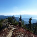
The trailhead is well-marked, and the trail is easy to follow. About 45 minutes of hiking will take you up through the subalpine forest and along the ridge to the saddle at 2134 metres (approx. 7000 ft), with marvellous views of Crawford Bay and Kootenay Lake along the way. From the saddle you can gain the peak of Mt. Crawford (2340 metres, 7675 ft.) The route is not marked and requires a “scramble”, that means the use of hands as well as feet. The last hundred metres is very steep and requires scrambling up large broken rocks. However most reasonably fit people will be able to gain the peak and sign the record book.
Once back down to the saddle or col, the trail switchbacks down into a rocky basin. Continuing generally north you will soon see Plaid Lake, which you may have already seen from the peak of Mt. Crawford. A well-travelled trail will take you 2 km down to the lake, a descent of 293 metres (961 feet).
Two nearby peaks provide alternate hikes. There is a narrow trail up to the old repeater tower on the peak to the west. Or, a hike up the unnamed peak to the northwest will give you a glimpse of the little-known Little Plaid Lake, due west of Plaid Lake. Bring along a topo map and compass. As usual, watch out for bears and remember that you have to go back up to the saddle of Mt. Crawford for the trail home.